
As I had correctly guessed, the sheep I had seen only 200 metres earlier were the guardians of a genuine mountain treasure: the bottom part of what is best described as ‘Gornerland’ (if you, gentle reader, allow me such a coinage or, if not, the bottom part of what I shall simply have to refer to as ‘glacier land’ given that there are so many glaciers that feed into the glacier of Gorner, thereby making it the second largest glacier in Switzerland).
 [Click to enlarge]
Before my very own eyes (unless I am mistaken, as this was my first visit to this part of the glacier of Gorner, and I, therefore, had to look up some of the names prior to writing this entry) stood the Breithorn’s twin (Breithornzwillinge, 4,106m) and the Breithorn itself (4,164m), Triftji and its glacier as well as the lower Theodule glacier. The contrast of colours was truly arresting, heightened by the mist and the autumn grass.
 [Click to enlarge]
As such, I moved closer to the ridge so as to get a better view of the Breithorn mountain range, Triftji glacier (top), Triftji (the brown mass in the middle), the 19th century moraine created during the ‘Little Ice Age’ (see the ‘banana’ I have drawn), the glacier of Gorner and its mouth (bottom right) as well as the lower Theodule glacier (see the small patch of white in the top right corner).

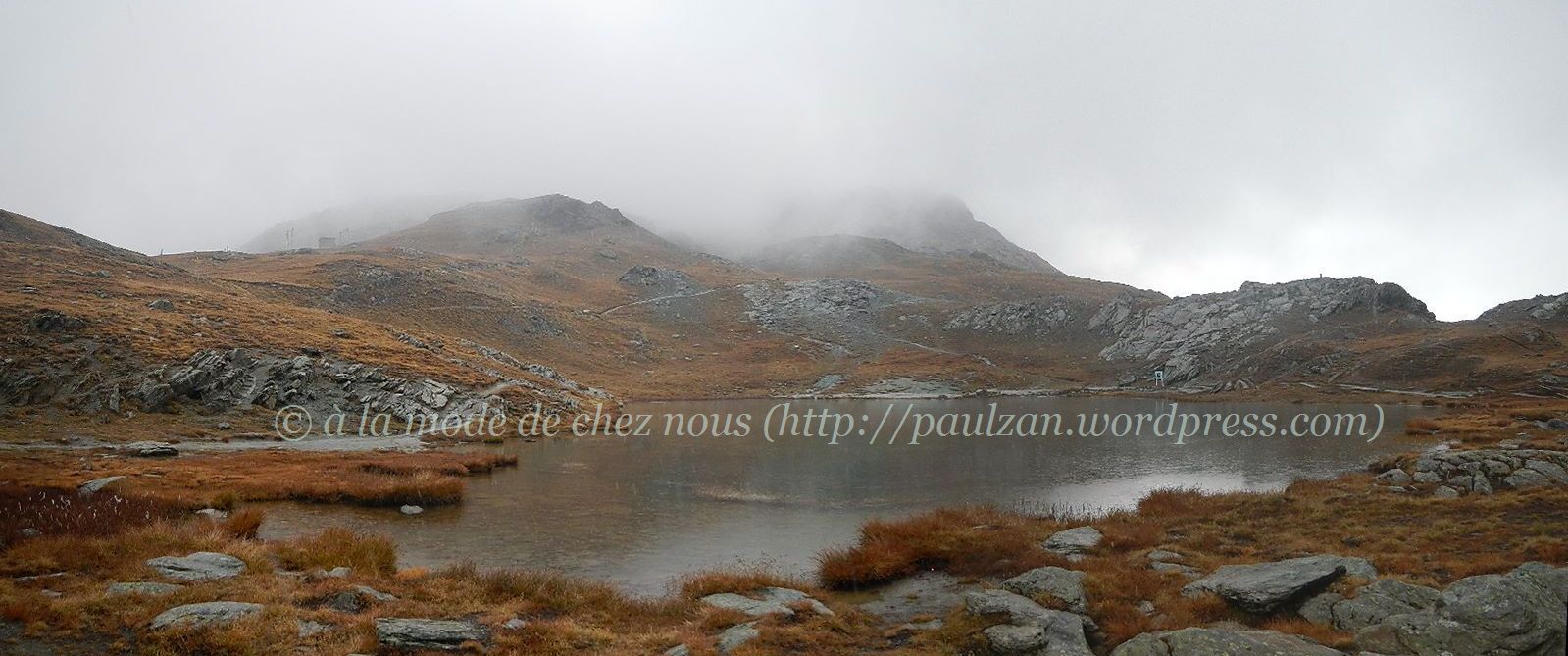
However, I had to carry on towards the goal of my outing, the tarn of Riffel. I was near Gagenhaupt (2,564m) and the tail part of the Riffelhorn (right) seemed almost like a huge, solidified flow of lava ending just in front of me. It had started to drizzle again and I feared that the rain might come down more heavily, which would then have made my journey downhill more dangerous. However, I decided that I would at least check on the signpost (visible on this picture) how far I was from the tarn (a mountain lake). The signpost indicated a distance of 50 minutes, which seemed reasonable. I nevertheless decided to increase my pace as I did not want to be caught in what was looking to be an impending downpour.
 [Click to enlarge]
16 minutes later, I shot this picture of the Riffelhorn, which although standing some 2,928 metres above sea level, seemed little more than a big rock and one that, from this vantage point, would seem to require little more than a leisurely climb. At its foot, there was another tarn which, unless I am mistaken, does not have a name, or is it called Riffelhorn tarn?
 [Click to enlarge]
From there, it was only a short walk to the larger and far more famous tarn of Riffel (Riffelsee in German). However, what a disappointment once I had reached the spot on the picture above, as the view to be seen normally from here is the one that adorns countless ‘Swissabilia’ (postcards, chocolate wrappers, mug-mats, t-shirts, you name it – in fact, it is probably one of the views which has come to epitomise Switzerland) with the Matterhorn reflected in the water of the tarn of Riffel [to see how beautiful it can be, check out this clip by Christian Mülhauser here].
 [Click to enlarge]
So I did not lose much time (I did not even go round the lake to look at the notice board) and I immediately headed towards the ridge. Unsurprisingly, there too the mist covered what is normally a breathtaking landscape. As you can see from the above picture, only a small patch of one of the glaciers was visible. So there was not much point hanging around. I decided not to run up to Gornergrat and then take a train down to Zermatt as I felt that it would have been almost cheating. After all I had come to Zermatt to do some exercise, not to enjoy train rides.
, 6 October 2013") [Click to enlarge]
[Click to enlarge]
A few metres away from Riffelsee I decided to take this shot of a dried-up tarn as I quite liked the palette of colours on display. Although I did not get to see the top part of the glacier of Gorner or the other glaciers which feed into it, I must say that I was quite happy with the landscape I had seen en route – it is not often that one gets to see these deep orange hues, right?

As the sleet had started to turn into tiny snow flakes, I decided to put on my gloves (I was already wearing the bonnet that is visible on my WordPress avatar). Although I had brought a rain jacket and the sleeveless top I got after having run the half-marathon of Aletsch, I decided not to wear them as I felt that it was better that I would change into some dry clothes only once back on the train (which I did and this is probably the reason why I did not fall ill despite having run in wet shoes for several hours).
, 6 October 2013")
Before me stood an almost lunar landscape down to Gagenhaupt (2,564m). Strangely, I was not alone on this path: there were a mother and her young son whom I had seen going downhill quickly before I had stopped to take out my gloves from my running rucksack and put them on. Once on the track again, I saw them coming back up and then climb a hill on my right but they were not walking on a path. I wondered whether they were lost and, in pidgin German, I queried whether I could help them in any way: ‘Alles OK? Brauchen Sie Hilfe?’ The young mother said something in Swiss German which I did not understand but she added that it was OK and she thanked me for my concern. I reluctantly left them as I felt that somehow I ought to have forced my help upon them. However, I also knew that the train stations of either Rotenboden (2,815m) or Riffelberg (2,570m) were not far away and that they were heading into the right direction (uphill).

After I had passed the huge rock a kilometre or so below Gagenhaupt, I found myself on a narrow path almost totally covered with some thick mist. Fortunately, a little later the mist had almost totally cleared.
 [Click to enlarge]
To my surprise (and delight), a little later near a bend, I came across a small herd of black collared goats and then a rarer subspecies: goats sporting tawny-coloured collars (chèvre au col fauve). These fellows were much less timid than their black collared cousins and they did not move away: they simply stared back at me unfazed (the close-up shot was not a zoom-in, I had simply moved my camera as close as that!). According to ProSpecieRara, they are bred for their meat, which seems strange given that they are rare. I hope these animals will not be sent to the slaughterhouse as they were so lovely.

From there it was simply a matter of running downhill as fast as possible, but without taking on any unnecessary risk. Soon Zermatt and the valley of Matter were visible again.

A little later on, it was the turn of the hamlet of Riffelap to come in sight, but the mist was starting to settle on this stretch too.

Fortunately, it had cleared again by the time I reached the most treacherous stretch, not long before Riffelap. I decided to take my sweet time and be extra cautious so as not to fall — I did not want a repeat of the fall I had experienced in the region of Aletsch!

However, as I was running down the last part of the woods of Vorderi, I came across this protruding rock which startled me a little. It was as if a man with a sharp nose and a moustache (almost Celtic features) was looking at me ominously (the seeing of such human traits in objects partakes of the more general phenomenon of pareidolia). Feeling that it would make a good picture, I decided to slow down a little and I slipped, but, fortunately, I did not hurt myself. So I retraced my steps and and took the above picture. About half an hour later, I was at Zermatt’s railway station, on time for the 6:13 (I would reach Lausanne 3 hours later). So this strange rock was not a portent of anything really negative after all.

I really look forward to being able to run again in this area; however, this might not be before some time as there already seems to be some snow at Riffelberg (see webcam). Just for illustrative purposes, the above screenshot of the brochure ‘Adventure in the mountains’ by Zermatt’s tourism office, illustration Kettler, shows the route I took on Sunday 6 October.
Other runs near glaciers:
- De retour à Zinal … 2ème partie (du Petit Mountet au glacier de Zinal)
- De retour à Zinal … 1ère partie (jusqu’au Petit Mountet)
- De Belalp au refuge d’Oberaletsch le long de la Panoramaweg … le pied géant !
- Back in Aletsch for a run on Swiss National Day
- Running in the UNESCO-listed area of Aletsch
- Aletsch half-marathon, 30 June 2013
Wife’s entries on Gornergrat:

Pingback: Matterhorn trail… from Zmutt to Momatt and back to Zermatt… | Just Sharing ...