
Yesterday, I decided that I would make use of the long days we have at this time of the year (daylight until after 9:30 pm unless it rains) to go on an excursion I had been wanting to do ever since I saw a picture of this hike from Leysin to Tour d’Aï in Daniel Anker’s Lac Léman, Les plus belles randonnées [The best hikes in the Lake Geneva region], a book I had purchased on 14 January 2006 (I tend to use book receipts as bookmarks).
In October of last year, my wife and I had set off with this very purpose in mind … but I had not even bothered to read the entry on the hike in Anker’s book, to the effect that we ended up at the start point of the via ferrata, almost right below the peak of Tour d’Aï. As it was out of the question to take the via ferrata to go up this mountain, we would have had to do so from the western side of Tour d’Aï but we were a little short of time, so we decided to call it quits (read the account here; there are several photos).
As a result, my feet had been itching to return to the area ever since. To be honest, I am a little stubborn by nature and, generally speaking, I tend not to like to give up when I have set myself an objective. As I was wondering on Monday where I could go for a run in preparation of Sierre-Zinal, it suddenly dawned on me that Leysin would be the perfect destination for such mountain training as it is only a little over an hour by rail from Lausanne.

In addition, it would be the opportunity to try out a pair of Adidas Kanadia I had bought heavily discounted (to CHF32.90) in the sales last autumn. So I left work a little early and boarded the 5:21 train from Lausanne (Geneva to Brig). I got off the train at Aigle and boarded the smaller, cogwheel train to Leysin-Feydey.

[Click to enlarge]
The starting point for my little training session was a field towards the end of the village of Feydey, called Plan Praz, at approximately 1,400 metres above sea level. My watch read 6:24 when I started off on my little run.

I did not bother to take any pictures whilst running/walking uphill through the woods. It was only once I had reached a small road (called les Chamois) and that I caught a glimpse of the bottom part La Berneuse that I decided to do so. For anybody who would be tempted to go on the same excursion after reading this entry, please note that you should walk left from this point (altitude approx. 1,630m).

[Click to enlarge]
I continued running along this road towards the west until I reached the bottom of a meadow where there were cows grazing. The roads then loops round the meadow (most of which is on a hill) and leads uphill to a farmhouse as well as a barn for the cattle, called Le Temeley [where it is possible to purchase refreshments or see how cheese is being made]. Shortly after, I left the mountain road and followed a small path which zizags along the southern flank of the mountain of Geteillon (La Berneuse’s lesser known twin sister). While running uphill I only had to look down to be able to admire a superb mountain scenery with a full stretch of les Alpes vaudoises.

The terrain became a little rockier and thus provided me with the opportunity to put my brand new Adidas Kanadia to the test — with flying colours, to my relief. The pylons and cables for the cable car system were not far from sight during most of the path’s zigzagging course, thus making it extremely unlikely that I would get lost on this stretch.
 [Click to enlarge]
Once I reached the top of Geteillon (altitude 2,018m), I could see the mountains above Lac Léman on the French side (left) as well as the revolving restaurant (Kuklos) and the cable car station on the summit of La Berneuse. I had started my climb about 70 minutes ago.
 [Click to enlarge this super wide, almost 360° panorama]
The scenery was truly breathtaking and I felt that it justified a short break so as to try to capture as much of it as possible with the proper lighting. From Geteillon, it was a matter of running downhill and then uphill again …
 [Click to enlarge]
Once in the area at the foot of both the Kuklos (the revolving restaurant that sits on top of La Berneuse) and the cable car station, I decided that I would run downhill as fast as possible so as to avoid the mistake we had made in October, i.e. venture towards the northeastern flank of Tour d’Aï. Instead, I would keep on my right while running downhill so as to get to the bottom of Tour d’Aï more quickly.

A few minutes later, I was facing Lac d’Aï and the eponymous mountain, which looked impressive, almost as if it had been built by some cyclopean hands. Notice how small the chalets on the right seem from here – in (Swiss) French, they are called mayens. I continued along the path on the right, as it seemed to be the fastest route to the chalets: it was already ten to eight pm.
 [Click to enlarge]
So I quickly ran downhill until I reached this point past the small lake, which I felt deserved to be captured on ‘digital film’. The flank of Tour d’Aï that is visible on this photo (i.e. on the far right) is called the ‘wall of the sphinx’. The nickname seemed totally appropriate, as to me the mountain indeed looked like some monster lying in wait for its prey …

It can be easy to miss the path leading to the summit of Tour d’Aï, as it starts right behind one of the chalets of the hamlet of Aï. It then follows the southern flank of the mountain until it reaches a passage between the rocks. The white and blue sign indicates that the path is dangerous and that only hikers wearing proper equipment and with some prior experience of walking in such alpine environments should go on this hike.

Almost so as to give one a foretaste of what to expect once on the ridge of the mountain, a difficult passage with some nasty-looking rocks to navigate through awaits the visitor right at the start of the climb of Tour d’Aï – I was even more grateful for this rope on my way back down, when every minute was precious to me as I had not much time left to catch the train back home.

Shortly after I had started my climb (a few minutes before this picture was taken to be precise), I came across an old man in full hiking gear who was coming down. I greeted him with a friendly hello and queried how long it would take to reach the top of Tour d’Aï. He replied that it would depend on my pace, but that it would probably take me more than 30 minutes, adding that the difference in altitude amounted to some 300 metres. Before we said goodbye, he warned me to beware that the days were getting shorter and that night would be coming down from 9:15.
 [Click to enlarge this wide panorama of Alpes vaudoises]
I tried to run while going uphill, but I found the climb to be too steep. So I took out my water bottle and had a drink. I also took a few shots of the Alpes vaudoises which appeared to my eyes in all their splendour. The mountain with the white topping (a glacier) is called Les Diablerets (which peaks at 3,210m of altitude). La Berneuse and the Kuklos (far right) seemed far away from this vantage point.

I knew I had to move faster (it was already twenty minutes past eight) but the course was becoming steeper and steeper. Finally, the beginning of the ridge was in sight. I could see the metal ladder I would have to go up on. I dared not think whether it was the same metal railings which I had seen in a book I had bought on Alpes vaudoises, dated 1907 …

This meant that the railings were probably fixed in the nineteenth century … which did not make them feel 100% safe, at least to me! Fortunately for me, the ladder (on the left) seemed less ancient and this was enough to prompt me to climb the ladder.
 [Click to enlarge this wider panorama]
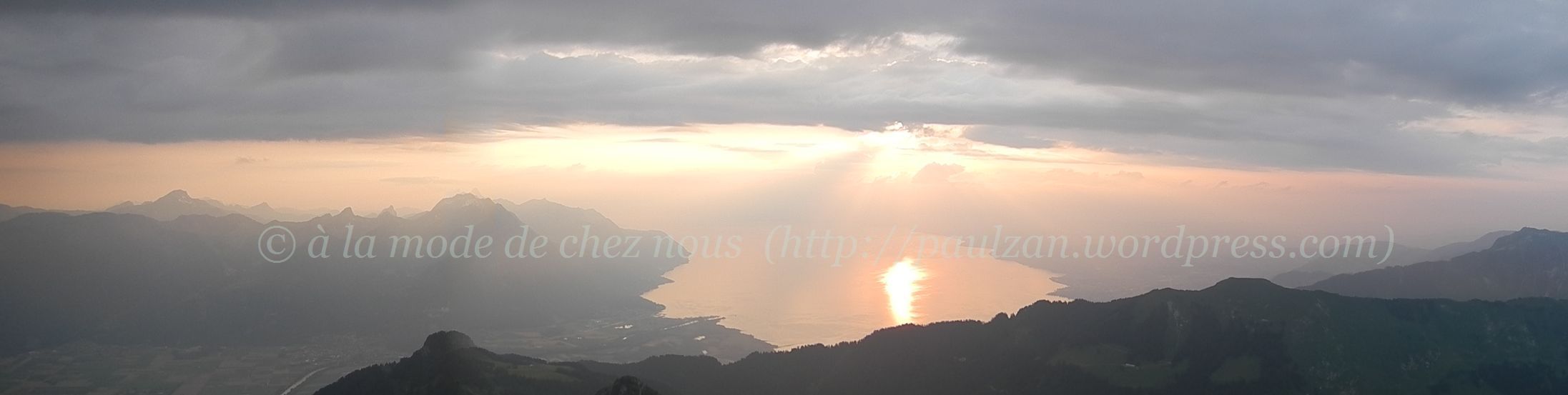
Once I had passed these two nasty stretches I was rewarded with a beautiful view again, this time of the sun starting to set on the lake, with the mountains of Chablais on the left and Tour de Mayen on the far right. However, before me was a long stretch of path without any railings … I hoped I would not fall prone to vertigo as I had done in October.

Below me, I could see the path (below the ‘l’ of paulzan) we had reached with my wife (also in October) where the via ferrata starts. But the path was wide enough, so I proceeded forward.

There were some more nasty-looking stretches with railings which definitely dated back to the nineteenth century. Fortunately, I did not come across anybody on this stretch.

I only did come across a mountain climber and then two trailers a a little further from this point, but there was a metal cable to hold onto. From this shot, it was only about a 4 minutes’ walk to the peak of Tour d’Aï.
 [Click to enlarge this much wider panorama]
And then I was rewarded with this beautiful scenery, some two hours and fifteen minutes after I had left Plan Praz. There were even some patches of snow below (on Sex du Parc aux Feyes).
 [Click to enlarge this wider panorama]
The view behind me …
 [Click to enlarge this wider panorama]
Of course, I would have stayed there until day dawn if I could have done so (people are not allowed to camp) 😉 As this was not possible, it would have been really great if I could have spent longer to soak up as much as I could of the beauty and probably of the energy there … but I had to be back in front of my computer to work the following morning and I had about 68 minutes to reach the train station.

Of course, I walked cautiously along the dangerous stretches on the ridge … but I started running immediately afterwards as I did not want to miss the 9:58 train (which I later found out was the last one down to Aigle).

I reached the foot of Tour d’Aï in less than 30 minutes … but this gave me not more than 50 minutes to reach the station. And it was getting dark fast.

I took the track the mountain bikers cycle down at full speed … but there was nobody else except me … so I did not have to worry about bicycles possibly knocking me down.

In fact, I learned to let go and run downhill at full speed and I found this to be exhilarating.

Even when I had to run through the woods …

… although I doubt this would have been the case had I not brought a small torch with me!
I reached the station in 65 minutes and I was thus able to catch the train back home. I reached home at 11:20, but I could not sleep until 3:30 am. If the weather had not been bad this evening and if I had not been tired today, I think I would have gone back today already!

Related entry:

We can see on the pictures how the landscape is cleaned and the pathes have been secured by the mounteneers of Leysin to permit to the tourists runners and to the climbers to make tourism until top of summits
Yes, this was done so already some time ago -i.e. the path being made safer thanks to the railings.
There is a picture of a group of climbers by Fred Boisonnas, at the turn of the 20th century here: http://archive.org/stream/lesalpesvaudoise00vaut#page/n7/mode/2up So the place was already getting visitors more than a hundred years ago.
Here is the link for the PDF of the Leysin’s tourist info centre for summer walks in the region: http://www.leysin.ch/files/?id=63382
Pingback: Celebrating the start of autumn on La Berneuse … | Just Sharing ...